Imaging on the Geospatial Web Using JPEG 2000
Michael P. Gerlek • Matthew Fleagle
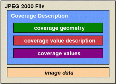
As geospatial imagery becomes more available and more commonly in demand as an indispensable part of the geospatial community's workflows, new solutions must be found for overcoming the barriers that have marginalized image data in the past – in particular, the compression of massive image sets without loss of quality and inclusion of the geographic metadata that would make imagery “spatially aware”. The relatively new JPEG 2000 standard is ideally suited as a delivery technology for geo-referenced imagery, but a few features are still required for use in the Geospatial Web, including a mechanism for representing geospatial metadata and bandwidth-aware standards for client/server interchange of image data. This article discusses JPEG 2000 and gives examples of some of the emerging technologies surrounding it – largely from the Open Geospatial Consortium (OGC) – which together make it the right imaging format for the Geospatial Web.
The Geospatial Web ▪ Copyright 2007 Springer ▪ ISBN: 1-84628-826-6
![]()
| Download |